Quote
"The only time you should ever look back is to see how far you've come."
Updated: May 18, 2019
Disclaimer: If this hike is not a part of the Na Ala Hele "State Maintained" Trails, it may be illegal or dangerous to hike, so do not attempt or HIKE AT YOUR OWN RISK. Hik3beasthawaii is not responsible for any injuries, fines, violations you may incur. This website is solely to showcase the beauty that nature has to offer on the island of Hawaii. *****
Location: Located in Hawaii Kai with a beautiful view of the Windward side. A more advance loop hike than the shorter Kuliouou Ridge hike.
Type: Forest/Ridge hike
Hike Difficulty: Advanced
Total Time: 5 to 6 hours round trip
Distance: ~5 miles
Elevation: ~2200 feet
Things to Consider
- Kid friendly: no
- Pet Friendly: no
- If you are looking for a more strenuous loop, than the Kuliouou Ridge hike, then this is the hike for you.
- Lots of rope climbing sections. Use caution on the ropes as some of them are weathered.
- Expect to take at least half a day on this hike. You may go clockwise or counterclockwise. We chose to go clockwise because it would be easier for us to go down the Kuliouou Ridge East.
- Bring pants if needed as some parts of the KST are overgrown.
- The hike can get pretty windy. It can be dangerous especially in the rope sections.
- Do not attempt this hike in the rain. It is dangerous and there will be no view from the cloud cover.
Your hiking backpack
- 2 to 3 Liters of water
- Snacks/lunch
- Gloves if needed for ropes and rock sections
- GoPro camera
- Sunscreen
Directions
Take Kamehameha Highway towards Hawaii Kai side of the island. Take a left onto Kuliouou Rd and follow the road all the way to the end. Take a slight right onto Kalaau Pl and the trail will be at the end of the road. Instead of taking the slight right up the the Valley and Ridge trail, continue on the paved road until you see the water tank. There will be a faint trail to the right of the tank. This is the start of the West ridge and the start of the Pu'u O Kona Loop.
Our Journey
If you are looking for an epic hike with breathtaking views then this is the hike for you! Kuliouou Ridge is the shorter route to the beautiful view of the Windward side. However, Pu'u O Kona completes the loop from the West ridge to the East ridge. We chose to go from West to East (clockwise) for a couple of reasons. We had a late start, at around 12pm, so we wanted to make it down in familiar territory. We also have not done the West ridge so we might miss the turn down from the KST if we had done the opposite direction. So with that in mind, we started up past the water tank up the ridge through the forest section. Within a half hour or so, the forest turned into a clearing and we could see the ridge we were going to hike up to the KST. As soon as you are out of the forest, the winds pick up, and during the time we went, the winds could hold us up doing a Michael Jackson thriller move! It was literally like 20 to 30 mile an hour winds! Not sure if that was normally how the weather is over there, but we almost decided to turn back. However, we pushed forward and went through the rope sections. They look more scary than they actually are. The route contours around the left of the boulder so it isn't too bad. And the wind is pushing you in the opposite direction of the cliff so it wasn't as bad as we thought. After almost 2 hours we finally reached the KST! And what a beautiful view it was! The trail is always narrow on the KST so we moved at a pretty slow pace. We took lots of pictures. There is also a nice spot to relax where you can see Bear Claw Ridge, the left and right forks. I have still not attempted that hike, but one day I will. The hike wasn't over yet and what seemed like forever turning left and right along the KST, we finally reached familiar territory. And we finally saw another human being for the entire duration of the hike, which was comforting. The hike back down the East ridge was tiring on our legs from the strenuous West ridge, but I'm glad we were going back down the East ridge with the easier switchbacks. We finally made it down to our cars right before sunset. What an epic adventure! I would definitely go back to do this hike again.
Heading up past the water tank into the forest.
The forest can get a little tiring with steep inclines heading up to the ridge.
Enjoy the shade while it lasts! After you are out of the forest,
there will be no trees to block the hot sun rays.
The trail is fairly distinct, so you should have no problem following the path.
The trail is starting to look like a Hawaii Kai hike! I love this scenery.
We took a short rest here, the inclines up to the ridge were pretty brutal on our legs.
Our first spectacular view out of the forest!
So much different scenery on this hike. It is a great experience!
Getting closer to the ridge section.
Finally out of the forest. Looking back towards the ocean.
Another forest section??
Took us about an hour an a half to get out to the ridge section.
The view looking back was amazing!
The ridge heading up to the KST in the distance.
Just another short forest section until you reach the first rope section.
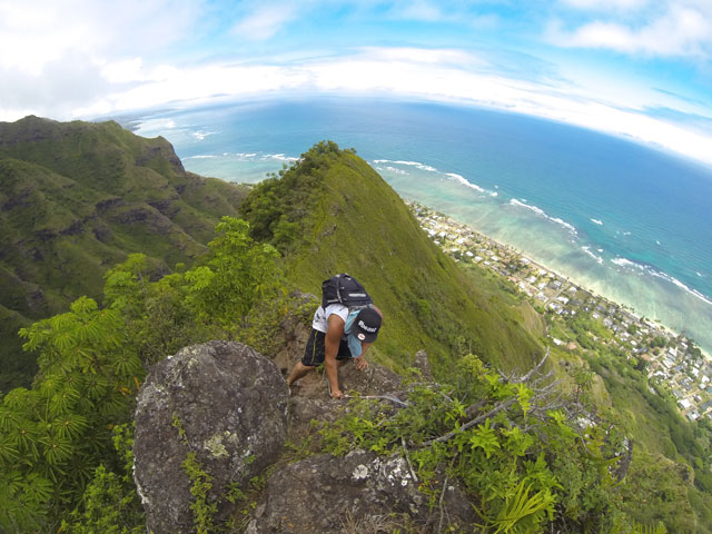
At first, it can look really intimidating.
The winds were super crazy! They could literally hold up my weight!
We had thoughts of turning back, but we decided to push through!
As we got closer, we could see the contour was around the left side of the boulder.
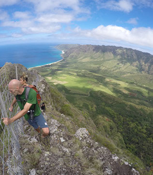
The first rope section.
The rocks are loose here and the rope is attached to a fragile tree.
Be careful when putting weight on the rope.
We went up one by one.
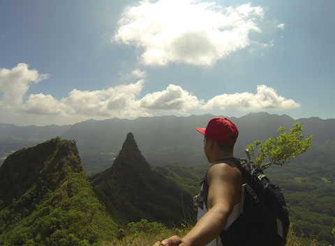
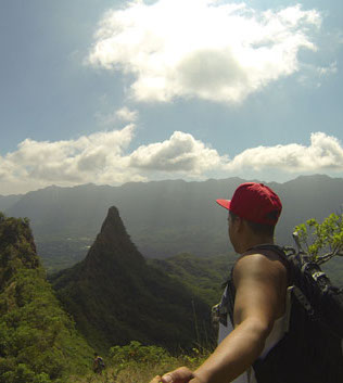
What a view at the top of the climb!
Gotta take a selfie at the top.
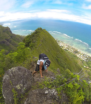
The final climb to the KST.
And we made it!
I'm glad it wasn't too cloudy today!
Looking down at the Windward side.
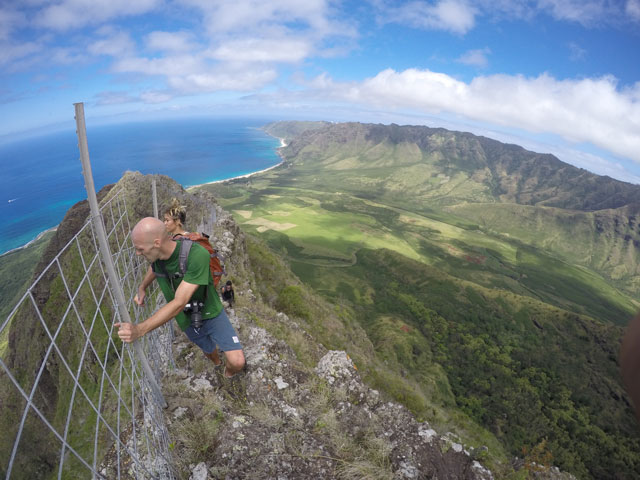
Take a right on the KST to head back towards Kuliouou East.
Feeling great on the edge! The wind blowing in our faces!
Watch your step! And definitely don't look down like I did!
The KST portion of the hike can be a bit overgrown.
The difficult portion of the hike is over. Smooth sailing from here on out.
Steep drops on both sides. Watch ever step you take because you never know if the brush is covering a steep drop off.
Looking back at the KST. Such a beautiful mountain range!
We came to a small lookout point, where we took some group pictures.
I'm pretty sure this is the point where Bear Claw Ridge connects with the KST. I have still not been able to do that hike, but will soon enough!
Helicopters were circling over us. I guess looking for a lost hiker?
And what an awesome spot for a picture!
Another 30 to 45 minutes before we reached the Kuliouou Ridge lookout.
Felt like the king of the world!
The part after the lookout was very overgrown getting to the Kuliouou Ridge spot.
We got a lot of scratches on our legs.
You could head back the way you came, or complete the loop going down Kuliouou East. I thought that was the better and easier choice.
Add a comment about this post! Was it helpful? Love the hike? Comment below.

Since 2014